
17 February 2017
Last updated at 10:08
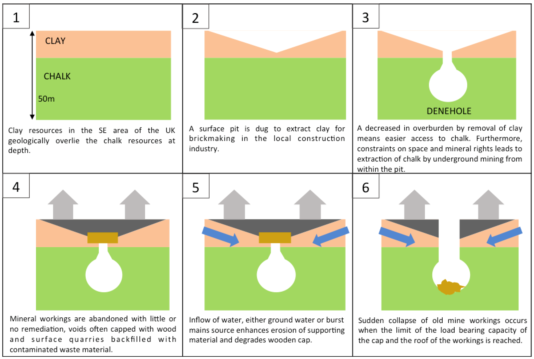
The term mining refers to the extraction of valuable mineral resources from the earth in response to a demand for a local, regional or global industry, such as manufacturing, construction or energy. Historically, significant settlements and industry grew due to the proximity of valuable mineral resources, particularly during the Industrial Revolution. Over 60 minerals have been exploited in the UK and during the construction of towns and in the development of industry, these resources, including clay, metals, chalk, stone and coal would have been extracted from the immediate vicinity to avoid the costs associated with transporting the minerals.
A mining legacy can have a significant environmental impact including erosion, localised subsidence, the formation of sinkholes, contamination of soil, groundwater and surface water by chemicals from historical or current mining processes. The impact may only be felt some hundreds of years after the initial mineral extraction, often exacerbated by new development or redirection of watercourses.
There are records of over a hundred thousand old mineshafts in the UK, most of which don’t cause problems for properties nearby but there is a risk that they could potentially affect the structural stability of a property either now or in the future.
Since its formation in 1835, The British Geological Survey (BGS), through its affiliation with the Health and Safety Executive, has been collecting locational and other information about operating mineral workings in the UK. Records relating to the location of many, but not all, coal mine shafts and adits are maintained on a register held by the Coal Authority (TCA). Other types of mineshafts are not fully documented or recorded in a central resource and professional interrogation is required to assess the likelihood of a risk.
Those properties located near old coal mines in England, Scotland and Wales (not Northern Ireland) are generally subject to a certain degree of reassurance. The Coal Authority has a duty to remediate any subsidence to a property caused by proximity to a coal mineshaft for which it became responsible when it was nationalised in 1947, however this does not apply to any type of mine other than coal and brine.
What is the impact of mining?
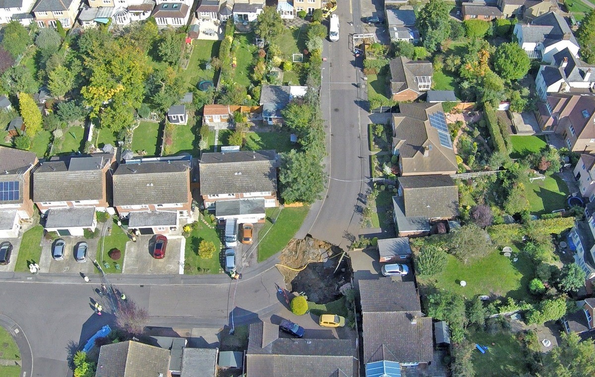
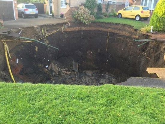
If we take a look at a recent example from 1st October 2015 in Fontmell Close, St Albans. A sinkhole approximately 130m2 opens up in the street between property numbers 8, 9 and 11.
No properties were directly affected, so insurance claims were limited to just two weeks alternative accommodation costs, but the surrounding land and street was severely impacted:
A property being marketed for sale in Bridle Close, St Albans adjoining Fontmell Close was in the process of conveyance at the time of the incident and according to Land Registry completed 14 days later. The new owners would have moved in and had the
impact of the sinkhole in the street until a year later when the repairs were completed and residents returned to their homes.
What would a mining search with a professional opinion have identified?
What is a mining search?
Not to be confused with Environmental, Flood or ground stability reports, mining searches have been around in some form since the 1940s and the national coal mining database was created prior to creation of the Coal Authority. When asked what a mining search covers, most people refer to Coal, Cheshire Brine or Tin and consider the risk to be very specific to certain regions.
The reality is that there are over 60 different types of mineral extraction that have been carried out over thousands of years, across all regions of England and Wales.
As such, a mining search should look beyond coal in order to consider the risks posed by other types of mining activity, such as clay, lead or chalk, all of which are significant factors in the ever-increasing number of sinkholes and mining collapses that we frequently read about.
It is also common for areas to have multiple types of mineral extraction in the same location, so, for example, a clear CON29M report does not mean the location is free from other mining risks, as these are not assessed within the report.
Mining search enquiries are necessary even when there are no obvious signs of mines existing in the area: when mines are closed they leave little or no residual evidence on the surface, but can still cause major problems for land and property owners.
Furthermore, when looking back through history, much of the mining was undertaken in the 19th Century, upon which the Victorians subsequently built towns, using the very same minerals, for example clay and chalk, to create bricks and cement.
The majority of mining searches in England & Wales are based on a distance risk matrix around features recorded on historical records within the radius of a point or boundary. The limitation of just querying data is that some linear features (e.g. mineshafts and coal seams) or points where features are located can fall outside the search radius and be excluded from the analysis. When a professional interpretation is provided, these features provide valuable hidden insight to other potentially unreported linear features and risks that can change the outcome of a professional opinion within the report.
Why is a mining or mineral extraction search an important part of conveyancing?
Where minerals are presently being mined, or have been mined in the past, there may be a risk to the property above and the future development of property on that site. In order to ensure the owner continues to have quiet enjoyment of their property, they should also be made aware of planned mineral extraction, even though this may not be readily apparent from planning proposals.
If conveyancers and other property professionals are to give the best possible advice to their clients, it is recommended they access the most current and property-specific information.
It is not reasonable to expect conveyancers to be able to advise on geological risks to property when it is not their core area of expertise, there are now specialist mining-instability risk assessment solutions available which include professional opinions that can be relied upon. These are able to assist conveyancers in their due diligence and protect the borrower(s) and lender.
The Council of Mortgage Lenders website provides information to Consumers on Issues affecting lending decisions where properties are close to mineshafts. It states “While a record of the location of many coal mine shafts is maintained on a register by the Coal Authority, other types of mine shaft are not fully documented, so in areas of risk, lenders may require additional reports before deciding whether to lend.”
To date the most commonly purchased mining report is the Con29M Coal Search, provided by the Coal Authority and in 2015/16 annual report there were 345,818 searches carried out in known Coal Mining areas. Conveyancers also purchase other Non-Coal specialist mining reports e.g. Tin or Clay when they are recommended by their search supplier but this is not providing conveyancers with the whole picture on mining risks to properties as it is a small number of minerals being analysed.
More recently the Coal Authority has made its data available to third party commercial organisations who can now incorporate that data into an All Mining Risks report with Con29M-compliant coal sections.
Throughout the 19th Century, mining was undertaken by private companies formed to undertake mining in specific locations. Once the mine was exhausted, the entry was covered and the site made to look as though unaffected. The private company would then be liquidated, to avoid potential future liabilities. Because of its national importance, coal extraction was brought under Government control in 1947, when many of the larger coal mining companies were nationalised.
History of The Coal Authority (TCA)
In 1994, the nationalised UK coal industry was privatised. The Government required a specialist body to manage the long-term effects of coal mining on safety, property and the environment.
The Coal Authority (TCA) is a non-departmental body, subject to Department of Business, Energy & Industrial Strategy (BEIS) control.
The Government set up TCA to centralise the provision of information on coal mining, which for the most parts has in turn been made available through mining reports. The Authority has worked with the Association of British Insurers (ABI), the Council of Mortgage Lenders (CML), the Law Society of England and Wales, and the Royal Institute of Chartered Surveyors (RICS) to produce a Con29M search suitable for the needs of conveyancers and property professionals. TCA also provides a service to the Cheshire Brine Subsidence Compensation Board, forming part of the complete CON29M reporting service.
The Con29M covers past, present and future coal and brine extraction. Whilst the report contains results of historical coal and Cheshire brine related subsidence claims made to TCA and the CBSCB. These claims relate to the property being searched, adjoining properties and other claims within 50 metres. The CA 2015/16 Annual report states the CA accepted liability for 47% of claims received. These are where the claim solely relates to coal and brine extraction but where they are rejected it is often related to other types of ground stability issues.
History of access to Public Sector data
In June 2009, Sir Tim Berners-Lee, inventor of the world-wide web, met with the then-Prime Minister, Gordon Brown, to discuss opening access to Government data.
The Office of Public Sector Information (OPSI) was formed and introduced the Open Government Licence (OGL), allowing free re-use of public sector information (including Crown Copyright information), for personal or commercial use.
OPSI also formed the Information Fair Trader Scheme (IFTS), which sets and assesses standards for public sector bodies. TCA were an early adopter and supported the Re-use of Public Sector Information Regulations 2005 (PSIR).
A complaint was made in 2011 that TCA were not complying with PSIR. This was partially upheld and triggered the first of several steps towards the availability of TCA data as it stands today.
TCA started to make limited data available on an internet web viewer under the OGL, but over-rode the licence conditions, saying “re-use is not permitted for any activity that is part of the Coal Authority’s public task responsibilities”.
The over-rider was subsequently revoked, but the OGL still provided access to limited data.
It took a further six years before the 2015 IFTS report stated:
“Now, TCA has revised its strategy to permit third parties using and re-using its underlying data for the purposes of producing CON29M-compliant mining reports and other types of mining report. Third parties may be supplied with the underlying wholesale data and produce their own reports.
“….. this is a significant step forward and represents a genuine attempt to create a functioning market in the provision of mining reports.”
TCA then allowed interested commercial parties to licence the necessary data to produce coal mining risk assessments. However, insufficient data was made available to create residential or commercial “CON29M-compliant” reports, as certain datasets contained personal information contrary to Data Protection Act.
What has changed to see the Launch of new Personal Mining searches?
In December 2015, further data was released by TCA including the “personal data” under the Data Use Licence only, allowing innovative private sector businesses to produce competitive “CON29M-compliant” reports for the first time.
In late 2016, Council of Property Search Organisations (CoPSO) formed a mining working group to engage with stakeholders including TCA. The key objective for the group is to set and maintain standards for personal mining searches carried out by firms registered under The Search Code and monitored by the Property Codes Compliance Board (PCCB).
The 2015 IFTS report also recommended that TCA should keep OPSI informed of progress towards the establishment of real time third party access to its database. TCA have committed to wholesale data being accessible up to the minute.
Conclusion
It is difficult to rely on local knowledge as appropriate due diligence for mining or ground stability risks to a property. Professional geologists have access to several hundred datasets to make an informed assessment of risk from over 60 different types of mineral extraction going back over hundreds of years. Conveyancers, Mortgage Lenders and Home owners should look for reassurance that the most comprehensive datasets are being analysed to cover all risks to ensure they understand the impact to their property or asset that the loan is secured against.
The full range of Terrafirma reports is available to order now from PSG. We are also integrated directly with their unique TerraSearch® alert which is available free of charge via PSG Connect.
For more information, contact your local PSG office.
No events were found.